Garmin GPSMAP 79sc Marine Handheld GPS, Rugged Floating Design, Preloaded BlueChart g3 Coastal Charts, 3-Inch Sunlight-Readable Display, Multi-Constellation Satellite Support


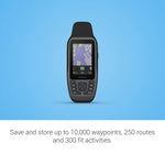
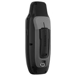


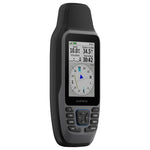

The Garmin GPSMAP 79sc marine handheld GPS is engineered for adventurers who demand dependable navigation on the water. Its rugged design is both water-resistant (IPX7) and buoyant, ensuring durability and safety during marine activities. The high-resolution 3-inch transflective color display is sunlight-readable and protected by scratch-resistant, fogproof glass for optimal visibility in diverse weather conditions. Preloaded with BlueChart g3 coastal charts, this device delivers detailed and integrated Garmin and Navionics data for superior coastal navigation. It supports multiple satellite constellations—GPS, GLONASS, Beidou, Galileo, QZSS, and SBAS—providing enhanced accuracy and reliable positioning worldwide. With expanded memory capacity, users can store up to 10,000 waypoints, 250 routes, and 300 fitness activity files. The built-in 3-axis tilt-compensated electronic compass maintains accurate heading information even when stationary. Additional features include a barometric altimeter for precise altitude tracking and compatibility with microSD cards up to 32 GB for map expansion. Powered by user-replaceable AA batteries offering up to 19 hours of operation in GPS mode, the GPSMAP 79sc combines robust performance with user-friendly functionality for seamless marine navigation.
Equip yourself with the Garmin GPSMAP 79sc today for dependable marine navigation that keeps you on course wherever your adventures take you.
Product Dimensions:
1.67 x 2.67 x 6.85 in
0.62 lbs
Shipping Dimensions:
3.67 x 4.67 x 8.85 in
YOU MIGHT ALSO LIKE